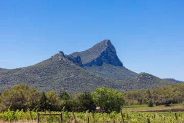
The terraced vineyards of Carema can be visited along a 4 km loop trail called ‘Sentieri dei Vigneti’ marked by yellow signs. The path proceeds between stone walls, mountain cliffs and small roads running alongside the vineyards. It’s a veritable labyrinth connecting the terraces to each other via small stairs and tiny paths that respect the mountain’s contours.
What will you be able to see

It takes just over 2,5 hours to walk the entire path at a leisurely pace, enjoying the view and the stops. If your are in the mood to walk more, it is possible to continue on to the ruins of Castruzzone Castle atop a rocky spur. It dates back to the 12th century and was destroyed in the 16th century during the war against the French.
This hiking itinerary accompanies the visitor to discover the hidden treasures and winemaking heritage of Carema. By walking along this “Vineyard Path”, the guest will be able to enjoy the typical local architecture that so strongly marks the Carema landscape and will be able to perceive the scent of the land from which the precious “Carema DOC” wine is born.
In addition to admiring the splendid views, you will also be able to take a break at the chapel of San Rocco dating back to the 17th century: the view here opens out over the natural basin, the terraced vineyards and the village of Carema. You will then be able to reach another chapel, dedicated to San Grato and called Siei Chapel, at the highest point of the trail at an altitude of 394 metres.
How to find Carema’s Sentieri dei Vigneti (Hiking Path)
The route consists of a circular itinerary, with a total length of 4 km and an uphill difference in altitude of 100 m, which uses some of the many paths of Carema and allows you to visit the main and most important emergencies at all times of the year of the country.
Once you reach the town of Carema, it is advisable to follow the signs for the sports facilities located in Via Torino, where it is possible to park on ‘Piazza Trattati di Roma’.
Then continue on foot, towards Pont Saint Martin (on the left) for about 400 m: just before the Esso service station, take the path on the right, located on the border with the Aosta Valley.
The route runs alongside the service area, bends to the left and climbs to the right, skirting a massive stone wall. After a series of curves through the vineyards, and having overcome some rocky leaps thanks to steps carved into the stone, you must pay attention to a fork in the road on the right and proceed towards it following the signs.

Follow me on my Social Media
Wine is a gourmet treasure, do not abuse alcohol!
None of this content has been sponsored
I did not receive any gifts or free samples that could be related to this article